Posts

Showing posts from April, 2020

scsvshsstclass5e(revision worksheet on Lat. & Long.)

Image
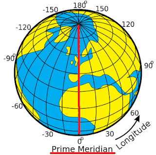
CLASS 5 SSt Thursday, April 30, 2020 LATITUDE AND LONGITUDE - REVISION WORKSHEET LATITUDE AND LONGITUDE      Good morning boys! It's time for some revision๐Ÿ‘‡       The locations on the Earth’s surface are determined by two reference lines known as latitude and longitude.         Let's compare these two lines ๐Ÿ‘‡                                                  Latitude Longitude 1.They run from East to West. They run from North to South. 2.It is known as parallels. It is known as meridians. 3.The length of the lines are different. The length of the lines are the same 4.It classifies heat zones. It classifies time zones. 5.There are 181 latitude lines. There are 360 longitude lines. 6.The largest latitude equator divides the earth into northern hemisphere and sout

scsvshsstclass5e(29.04 - quiz on continents and oceans)

Image
QUIZ ON CONTINENTS AND OCEANS Good morning boys! ๐Ÿ˜Š I'm sure you all are ready and excited for the quiz. But before we start, let's do a quick recap of the chapter:                             Continents and Oceans There are seven continents on Earth. They are: Asia, Africa, North America, South America, Antarctica, Europe and Australia.  There are five oceans in the world. They are: the Pacific Ocean, the Atlantic Ocean, the Indian Ocean, the Arctic Ocean, and the Southern Ocean. The Southern Ocean surrounds Antarctica. Asia is the largest continent and covers nearly one-third of the land area of Earth. Africa is the world's second-largest continent surrounded by water bodies on all sides North America is the world's third-largest continent, after Asia and Africa. It is surrounded by the Arctic, the Atlantic and the Pacific Oceans on the north, east and west respectively. South America is the fourth largest continent. It lies below North Amer

scsvshsstclass5e(27.04)

Image
LATITUDES AND LONGITUDES (PART 3)   April 27, 202 0 Good Morning, boys!! Hope you are completing all your written work and revising it too. Your work will be evaluated once we get back to school. Before we move ahead, let me test your previous knowledge. Answer the following in the comment box: The 0° longitude is known as ________ Line that marks the difference of date between the eastern and the western hemispheres.__________ Now let's move ahead! At the end of the lesson, you will be able to locate places on the globe using latitudes and longitudes calculate the time at a place using longitudes What kind of lines do you see on the globe? Yes, the latitudes and longitudes which you see on a globe form a network. This network is known as a grid. The grid helps us to accurately locate places on the maps and globes. The point where the latitudes and longitudes cross each other, helps us to know the exact position

scsvshsstclass5e(24.04)Latitudes and longitudes (part 2)

Image
              LATITUDE AND LONGITUDE  (PART 2) April 23,2020 A very good morning to you all ! Ready to continue with the lesson ! YES ! Before we move ahead ,we should recall what we've learnt yesterday. * latitudes are imaginary lines that run from east to west * equator, which divides the earth into two equal halves. Now, today we will learn about Longitudes.  On completion of the topic, you will be able to:- #define longitude # identify main lines of longitudes # know the difference between longitudes and latitudes Remember: The text in  red  will be the questions you need to answer in your notebook. The text in  blue  is to be written as it is in your notebook. The text in  green  will be the new words and facts to be written in the notebook. LINES OF LONGITUDES Longitudes are the imaginary lines that run from the North Pole to South Pole. These lines are not parallel, but are of the same length. All latitudes meet at the poles. Thes